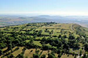
The Gergovia Plateau is a stunning natural viewing platform that offers a 360° vista across the Auvergne countryside. Covering almost 70 hectares, visitors can enjoy the breathtaking natural landscapes that extend from the Sancy massif to the Cézallier plateaus through the Chaîne des Puys and the Limagne Fault, recently listed a UNESCO World Heritage Site.
Walking the plateau footpaths involves taking a journey into the past. Gergovia is first recorded in history in texts written by Julius Caesar recounting the devastating defeat inflicted by Vercingetorix in 52 B.C. The Gallic site was rediscovered during the 16th century during archaeological digs. Since the 19th century, the Gergovia plateau has been under archaeological survey, which led to the uncovering of some of the spectacular remains of the Arverni stronghold.